Check out this article! Great information about the advantages of including a Cataloging and Classification course in your MLIS program of study.
– Angela

Check out this article! Great information about the advantages of including a Cataloging and Classification course in your MLIS program of study.
– Angela
This semester I am taking a special topics course, LIS 2970: Digital Humanities, taught by Professor Langmead. This class is focused on discovering, exploring, and utilizing different digital tools to reexamine humanities questions, with the emphasis on asking and developing questions. We are submitting three deliverables, focusing on examining the data set in two separate ways, providing insight to the question at hand.
One of the best parts of this class is that it was made clear very early on that our projects do not have to prove our questions or assumptions correct. Part of this process is developing a question, and finding or creating a data set that would allow you to explore the facets of that question. This is a critical skill considering once you enter the real world, you cannot expect nor would I really want to be given a prompt for every work task. It is critical to initiate a line of questioning, to look outside of the box and take a chance on examining an issue from another perspective.
Another great aspect of the class is that you get lots of time and reason to explore different digital tools! Below are some of the tools I have investigated. Most were found through Bamboo Dirt or sharing with classmates.
I have had the opportunity to spend several years in Pittsburgh as I completed my undergraduate degree and I am currently working on my Master’s. During my undergraduate studies I lived on campus and in South Oakland. Upon returning for my graduate degree, I knew that I had outgrown South Oakland. So I ended up in Shadyside!
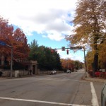

Shadyside is a great Pittsburgh neighborhood, very welcoming to young professionals and graduate students. Shadyside has several areas of shopping and restaurants along Walnut Street, South Highland Avenue and Ellsworth Avenue. There are several buses that run through the area, including the 75, 71B, 71D, and the P3. I am within walking distance of Target and three grocery stores: Giant Eagle, Whole Foods, and Trader Joe’s. For days when I need to be outside and remove myself from the hustle and bustle, I can walk to Mellon Park. Even more, Shadyside is home to a number of my classmates! If you’re an incoming student and not sure where to start looking for apartments, I would strongly suggest Shadyside, though I have a number of peers that are also happy in Squirrel Hill and North Oakland.
Also, if you are not familiar with the general lay out of Pittsburgh’s neighborhoods, please check out the Wikipedia’s Map of Pittsburgh neighborhoods. It does a pretty good job of outlining where each neighborhood is and you can click on each to get to an About page!
Powered by WordPress & Theme by Anders Norén